Dr. Krishna C. Devkota
The catastrophic disaster of August 26, 2026, along the Nepal–China border was a tragedy with enormous human and physical consequences. Beyond the immediate loss of lives and destruction of communities and infrastructure, it has raised a difficult question that Nepal and the wider Himalayan region can no longer avoid: are we adequately prepared for the kinds of extreme and rapidly evolving hazards that can emerge in our mountains?
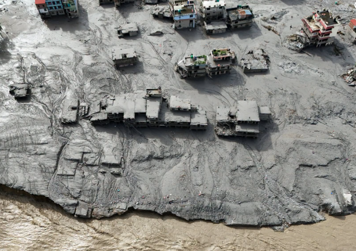
The scientific investigation is still continuing, and it is important not to draw conclusions beyond what the available evidence supports. Preliminary observations suggest, however, that this was not simply an ordinary flood or a single isolated event. A major failure high in the mountains, involving ice, rock and other materials, appears to have triggered a sequence of processes that developed into a destructive debris flow and flooding downstream.
A Cascading Mountain Disaster
In Nepal, we often speak separately about floods, landslides, avalanches and glacier-related hazards. Nature, however, does not necessarily work according to these categories. A failure high on a mountain can trigger another process, which can then trigger yet another. Ice and rock may move together, a river may be disturbed or blocked, and the moving mass can gather additional water, sediment and debris as it travels through steep valleys.
This is what makes a cascading multi-hazard disaster so dangerous. The greatest threat may not lie only in the original mountain failure, but in what happens afterwards. Each process can amplify the next. By the time the moving mass reaches settlements and infrastructure downstream, what began in a remote mountain area may have developed into something much larger and more destructive.
The lesson for Nepal is clear: understanding where a hazard begins is no longer enough. We must also understand how it can evolve as it moves through a mountain landscape. Where could the material travel? What might it encounter along the way? Could it block a river, mobilize more sediment or trigger another hazard? And who and what ultimately lie in its path?
The scale and speed of the disaster have understandably led many people to ask whether it could have been predicted. It is a fair question, but there is no simple answer. Scientific models are essential tools for understanding hazards and estimating possible impacts. Yet every model has limits. They depend on available data, assumptions and our understanding of natural processes that are often complex and constantly changing.
The challenge becomes much greater when several processes occur rapidly and interact with one another. We may monitor rainfall and river levels and identify potentially unstable slopes, but predicting the precise timing, size and consequences of a rare high-altitude mountain failure remains extraordinarily difficult. Some events will inevitably fall outside the range of what our existing models and previous experience can confidently anticipate.
That should not be seen as a failure of science. Rather, it is a reminder that preparedness must also deal with uncertainty. We need better models, certainly, but we also need real-time observations, satellite monitoring, hydrological information and systems capable of recognizing when something unusual is happening. We must prepare not only for the disasters we expect, but also for those that do not follow familiar patterns.
When Monitoring Fails
Perhaps the most important lesson from this disaster concerns the Early Warning System itself. Nepal has made significant progress in hydrological monitoring and community-based flood early warning, and these systems have helped save lives. But extreme events present a challenge that we do not discuss often enough: what happens when a disaster destroys the very infrastructure meant to warn us?
Imagine an upstream hydrological station transmitting data every few minutes. During an extreme event, the data suddenly stop. The immediate explanation might be a technical failure, and the system may simply record the situation as “data missing.” But if the information disappears during a period of heightened risk, should we not also ask another question: why did the data disappear at that particular moment?
The station may have been damaged, buried, flooded or swept away. Of course, every interruption in communication should not automatically trigger an emergency alarm. Equipment can fail for ordinary technical reasons, and unnecessary warnings can create confusion. But the sudden loss of a critical upstream station during an unfolding event should not automatically be treated as an ordinary technical problem either.
The failure of a monitoring station can itself become information. This is where we need to rethink and redesign our approach to Early Warning Systems. If an upstream station suddenly goes silent during a high-risk situation, the system could automatically trigger a heightened monitoring protocol downstream. Other available information—river levels, rainfall, satellite observations, automated cameras, seismic signals and reports from local communities—could then be brought together to assess whether something more serious is happening.
The missing signal should not necessarily mean an immediate emergency warning. But neither should it always be ignored as a simple technical problem. With appropriate safeguards and verification, the loss of communication can become one additional piece of information in assessing an unfolding risk.
We often design monitoring systems assuming that they will continue functioning during the very disasters they are supposed to observe. Extreme mountain events challenge that assumption. A flood can destroy a river gauge. A landslide can cut communication lines. A debris flow can damage roads, bridges and power supplies. When several of these things happen at once, a warning system built around a small number of instruments can quickly lose its ability to see what is happening.
The lesson, therefore, is not simply to install more equipment. We need systems designed with redundancy and failure in mind. If one station fails, another source should help fill the gap. If one communication channel is lost, another should remain available. Ground-based monitoring should increasingly work alongside satellite observations, automated cameras, meteorological information, seismic monitoring and community-based reporting.
An Early Warning System is not simply a collection of instruments. It is a chain connecting observation, interpretation, decision-making, communication and action. Technology is only one part of that chain. Institutions must know how to respond, information must move quickly, warnings must be understandable, and communities must know what to do when danger is approaching.
From Warning to Resilience
The August 26 disaster also reminds us that the danger may not end when the first destructive event has passed. A major mountain failure can alter river channels, create temporary blockages, destabilize surrounding slopes and generate new secondary hazards. Rescue and relief operations may therefore take place in a landscape that is still changing, where risks continue to evolve. Scientific monitoring must therefore continue well beyond the first emergency response.
The disaster has also reinforced the importance of transboundary cooperation. Mountains, rivers and disasters do not recognize political borders. Nepal and China may experience different consequences, but they can still be part of the same disaster chain. Faster sharing of relevant scientific information and stronger coordination are therefore essential, particularly in high-risk transboundary river basins. But information sharing alone is not enough; there must also be clear systems for turning information into timely action.
Ultimately, the purpose of recovery should not simply be to restore what existed before. Every major disaster provides painful but valuable lessons. If monitoring infrastructure failed, we need to understand why. If data stopped flowing, we must identify alternatives. If warnings did not reach people in time, we need to examine the entire chain—from observation and interpretation to decision-making and community action.
The August 26 disaster was, above all, a human tragedy. Behind every number are families waiting for news, people who have lost their homes and livelihoods, and communities whose future has suddenly become uncertain. Supporting those affected must remain the immediate priority. But alongside recovery, we have another responsibility: to learn.
We may never predict every mountain failure with complete precision, and we cannot eliminate all natural hazards from the Himalaya. What we can do is build stronger systems—systems that recognize uncertainty, use multiple sources of information and continue functioning even when some components fail. We can strengthen local preparedness, improve risk-informed planning and ensure that communities receive timely and understandable warnings.
For me, the most important lesson from this tragedy can be expressed simply: when the warning goes silent, the system should not go silent with it. The goal should not be merely to return to where we were before August 26. Nepal now has an opportunity to rethink how we understand cascading hazards, redesign our Early Warning Systems and strengthen scientific and transboundary cooperation. The next Himalayan disaster may not look like the last one. Our preparedness must therefore be ready not only for familiar risks, but also for the unexpected.
[The author is a disaster scientist and currently serves as Vice Chairman of the Gandaki Province Policy and Planning Commission (GPPPC), Pokhara.]